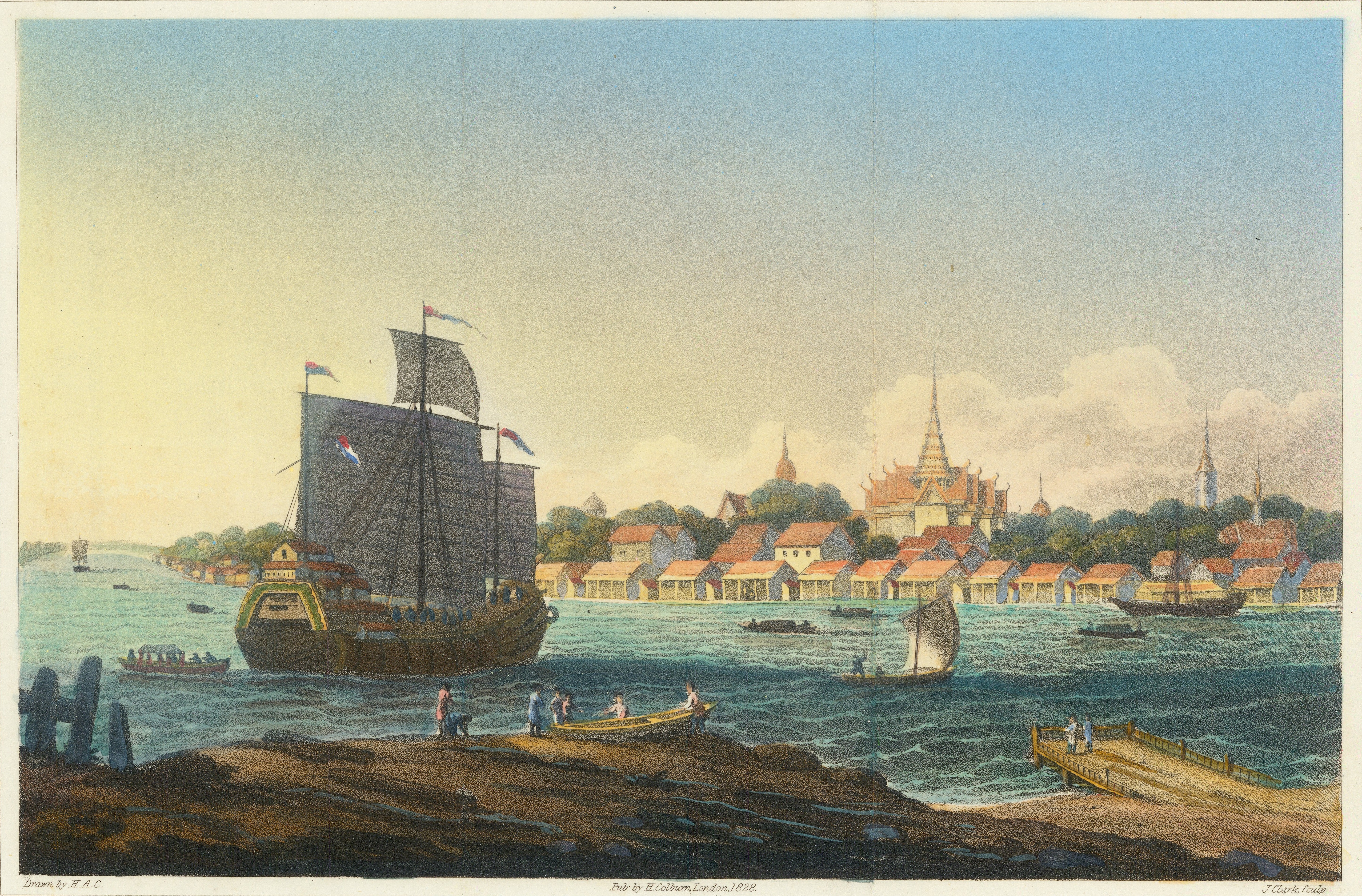
Original source : Cover image from View of the City of Bangkok in 1828, a coloured engraving by John Heaviside Clark (1771–1863), published in 1828. Source: Wikimedia Commons (Public Domain)https://upload.wikimedia.org/wikipedia/commons/6/6c/View_of_Bangkok_by_John_Heaviside_Clark_1828_Colored.jpg
Reading Bangkok Through Maps and Photographs
VDO
This talk, Reading the “City”, invites the audience to look at Bangkok—and Thai cities more broadly—through visual evidence such as maps, photographs, and urban landscapes. It presents the city as a layered space shaped by different historical periods, from the canal-based city of moats, palaces, and forts in the early Rattanakosin era to later phases of urban expansion. Drawing on field observation alongside the reading of different kinds of maps, including historical maps and aerial photographs, the lecture traces the growth of key areas such as Silom, Sathorn, and Charoen Krung, as well as the emergence of commercial land structures. In the final section, the speaker raises spatial questions that connect history with everyday experience—why Siam Square feels walkable, why tall buildings line the river, and how Ratchadamnoen Boulevard came into being—helping listeners better understand Bangkok’s past and present as part of the city they live in.Compiler : Chewasit Boonyakiet
Bangkok has developed through continuous change in settlement, urban planning, and economic growth. The city exists as a set of overlapping layers, built upon history and geography that have been repeatedly “written over” for hundreds of years. It began as a low-lying floodplain where water formed the main structure of life and movement. Over time, this watery landscape was reshaped, bounded, and filled with city walls, forts, roads, and eventually tall buildings. Reading the city, therefore, is like reading a text in which time is the ink and the landscape is the paper.
The Ideal City: From Tradition to a New Siam
Early Rattanakosin mural paintings show an image of the “ideal city”: a walled city with the palace at its centre, the residence of the king, surrounded by water that sustains life. These images are not only symbolic or imaginative; they reflect the real ecological conditions of the city. Located in a river delta, Bangkok was shaped by a water-based environment where canals and rivers functioned as the city’s lifelines. At this stage, it was truly a “water city”.
From the Gulf of Thailand up to Samut Prakan, Thonburi Si Maha Samut once served as a frontier city, controlling access to Ayutthaya. Cities were established by relying on rivers, canals, and natural geographical advantages. Ayutthaya itself was designed as an island city, encircled by both natural waterways and man-made canals.
After the fall of Ayutthaya, the capital moved south to Thonburi. King Taksin established the royal palace on the west bank of the Chao Phraya River, creating a city divided by the river and later described as a “split-chest city”. During the reign of King Rama I, the capital was relocated to the east bank, where an additional encircling canal—the “canal around the city”—was dug. This resulted in Bangkok having two layers of moats, along with city walls and forts. Today, Phra Sumen Fort and Mahakan Fort remain as visible evidence of this period.
Beyond the inner city, the surrounding areas were once open fields and farmland, such as Pathumwan, Phaya Thai, Maha Mek, and Bang Kapi. Over time, these areas gradually transformed into commercial districts, business centres, and parts of the expanding modern city. Bangkok’s growth did not occur solely through formal planning, but through development projects, population growth, and migration into the capital.
In this sense, Bangkok expanded outward from key sites of power, such as the Grand Palace, towards residential areas, commercial zones, and administrative centres. The historic core of Phra Nakhon began as riverside communities, from which the city gradually spread into the surrounding open fields, shaping the Bangkok we know today.
The City in the Evidence: Forts, Canals, and Photographs
When viewed from the top of the Golden Mount (Phu Khao Thong), the difference between the “inner city” and the “outer city” becomes clear. The inner city was enclosed by walls and moats, while the areas outside relied on canals as their main transport routes. The canal around the city connected to the Chao Phraya River in several directions, forming a circulation system that supported everyday life in Bangkok.
Photographs from the reign of King Rama V reveal a major transition from a water-based society to a road-based one. Wooden bridges were replaced by iron bridges, and single-storey wooden houses gave way to two- or three-storey buildings. The city grew denser along former canal routes, which gradually became major corridors leading eastwards.
The Grand Palace, the Front Palace, and major temples functioned as the main “pillars” of political and religious power. Images of King Rama IV travelling to Wat Phra Chetuphon in a royal palanquin reflect how architecture shaped and controlled public behaviour. Architecture, in this sense, was not merely about buildings, but acted as a tool of social and political authority.
At the same time, Bangkok has been a multicultural city from its very beginnings. Thai, Lao, Burmese, Chinese, and Western communities all played roles in building the city—as traders, labourers, and skilled craftsmen. The urban landscape thus emerged as a blend of royal rituals and the everyday lives of people living along the canals.
Reading the City as a Palimpsest: A City of Layers
Dr Peerasri proposes reading the city as a “layered text”, or a palimpsest—like medieval manuscripts written on animal skin, where earlier texts were scraped and overwritten but never completely erased. The natural layers of land, water, and vegetation form the first lines, upon which humans added houses, temples, roads, and commercial districts in later layers.
These layers have never disappeared. Instead, they leave traces that can still be “read” through observation, movement, and the use of all our senses. Learning to understand the city, therefore, requires walking, looking, smelling, and feeling—reading urban history not only with the eyes, but with the body itself.
From Canals to Roads: Cutting Across the Water Structure
Maps of Bangkok from the reigns of King Rama V to King Rama VII record a major shift in the city’s structure, from water-based to land-based. Surveys carried out by the Department of Lands and the Royal Thai Survey Department were not only for taxation or land titles; they also reflected a change in how the city was understood and managed. This marked a new way of thinking about urban space.
Former waterways were filled in and turned into roads. Charoen Krung Road—the first modern road in Bangkok—was built parallel to the Chao Phraya River, bringing economic growth to areas of rice mills, sawmills, and factories. At the same time, this process caused canals to become shallower, making it necessary to build many bridges to reconnect canals with the expanding road network.
The Pathumwan–Ratchaprasong area, once open rice fields, gradually became royal land, home to Wat Pathum Wanaram, and later developed into major commercial districts such as Siam and MBK. Silom and Sathorn provide clear examples of roads shaped by canal structures. In Sathorn, a canal was dug along the centre, and both banks were filled in to create North and South Sathorn Roads. In contrast, the canal in Silom was entirely filled, leading to the dense business district seen today.
Traces of former canals and fields remain hidden in street alignments and land plots. Together, these elements form layered “urban fabrics”, overlapping like patterns in a woven cloth. The new city did not replace the old one; instead, it was built by weaving itself into the existing foundations.
Reading the City Through Experience: Siam Square, the Riverside, and Ratchadamnoen
During the discussion session, the speaker encouraged the audience to observe the “logic of place” in areas they encounter every day.
- Why is Siam Square walkable? Because its street scale suits pedestrians, its grid is clear, and it includes strong attractions such as historic cinemas and Siam BTS station. This reflects land subdivision patterns dating back to the reign of King Rama V.
- Why are there so many tall buildings along the Chao Phraya River? Riverside areas were once large plots occupied by rice mills and sawmills. As economic conditions changed, these large parcels became suitable for major developments that require deep foundations and open space.
- Why is Ratchadamnoen Avenue wide and gently curved? King Rama V was inspired by European boulevards and chose a route that reduced the need for extensive land expropriation. The three sections of Ratchadamnoen Avenue connect the old palace with the new one, symbolising the modern state. Later, during the reign of King Rama VIII, the area developed into a key public and political space.
These questions help listeners “read” the contemporary city through historical logic, and to recognise that behind familiar urban forms, there are always deeper stories waiting to be discovered.
How to Read Maps: From Paris to Chiang Mai
Reading a city also requires understanding its representations. Dr Peerasri compares maps from different periods and places to show how each reflects a particular way of thinking about the city.
- Medieval European maps, such as those of Paris, depict buildings in three dimensions, seen from an elevated viewpoint, with north placed to the side rather than at the top.
- Eighteenth-century maps often use the figure–ground technique, showing open space in white and building mass in black, to study the relationship between architecture and public space.
- Special-purpose maps focus on specific systems, such as underground railways, or in the case of Rome, maps reconstructed from fragments of ancient marble slabs.
In Thailand, early maps were hand-drawn by local craftsmen in a diagrammatic style. Maps of Chiang Mai or Bangkok, for example, highlight key features such as forts, city moats, and major temples. Later, during the reigns of King Rama V to King Rama VII, mapping developed into systematic land surveys carried out by Western experts and the Royal Thai Survey Department. These maps recorded building materials, land-use colours, and detailed symbols, reflecting a modern system of land ownership and control.
Looking at a map, therefore, is not simply about finding routes. It is about reading the mindset of its makers—how they understood the city: as a physical environment, or as a symbol of power, order, and civilisation.
The City as Layers of Time
When we look at Bangkok through the lens of urban reading, we see more than streets and buildings. We recognise traces of water systems, palaces, rice fields, and ideas of power that have shaped the city’s form. This perspective turns moving through the city into an act of reading—each neighbourhood becoming a new chapter, from Phra Nakhon to Pathumwan, from the Chao Phraya riverside to Sathorn.
A city is never built just once. It is continually rewritten, layer by layer, over time.
Source
This video and accompanying text are adapted from the lecture “Reading Bangkok Through Maps and Photographs” by Assoc. Prof. Dr Peerasri Powathong, delivered as part of the Museum Link programme. The lecture was organised through a collaboration between the National Discovery Museum Institute (NDMI) and the Demonstration School of Thammasat University, and took place at Museum Siam on Saturday, 21 June 2025.
The lecture formed part of a museum-based and place-based learning programme aimed at developing historical thinking skills through the interpretation of maps, photographs, and urban landscapes. It approaches Bangkok as a city shaped by overlapping layers of time, geography, and social structures, encouraging learners to read the city as a living historical text.
Assoc. Prof. Dr Peerasri Powathong is a faculty member at the Faculty of Architecture, Chulalongkorn University. He is a specialist in Thai and Southeast Asian architectural history and theory, with a particular interest in viewing cities and buildings as forms of living history. His work spans both academic research and creative practice, including the Chulalongkorn University Architectural Heritage Project, the architectural history publication Suan Dusit Palace, and the article “Bangkok: Challenges and Innovation of the Urban Future”. In 2019, he received the Outstanding Thai Heritage Conservation Award.
- National Discovery Museum Institute
4 Sanam Chai Rd., Phra Nakhon, Bangkok 1200 THAILAND
- Opening hours: at 10.00 a.m.- 6.00 p.m. Tuesday-Sunday (closed on Mondays)
- Tel. : 02 225 2777
- Fax. : 02 225 2775


